


Latest Version
Version
2.12.0
2.12.0
Update
June 05, 2025
June 05, 2025
Developer
NextGIS
NextGIS
Categories
Internet
Internet
Platforms
Android
Android
Downloads
0
0
License
Free
Free
Package Name
com.nextgis.mobile
com.nextgis.mobile
Report
Report a Problem
Report a Problem
More About NextGIS Mobile
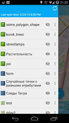
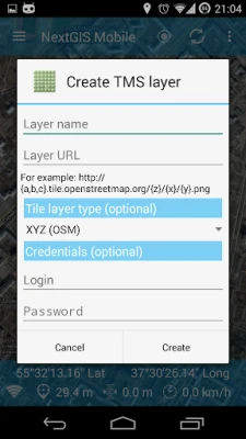
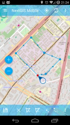
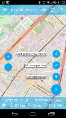
NextGIS Mobile is a geographic information system for your mobile device that can:
- show multi-layer map (layers can come from online and offline sources)
- change visibility and layers order
- navigate the map (panning, zoom in, zoom out)
- edit vector data (both geometries and attributes) online and offline
- record tracks
- show coordinates, speed, elevation etc.
- change visibility and layers order
- navigate the map (panning, zoom in, zoom out)
- edit vector data (both geometries and attributes) online and offline
- record tracks
- show coordinates, speed, elevation etc.
Rate the App
Add Comment & Review
User Reviews
Based on 0 reviews
No reviews added yet.
Comments will not be approved to be posted if they are SPAM, abusive, off-topic, use profanity, contain a personal attack, or promote hate of any kind.


More »

Popular Apps

Systema Martial Art TechniquesHalfway Home Company

YAHTZEE With Buddies Dice GameScopely

Keys Cafe - Make your keyboardYM, Inc.

Google News - Daily HeadlinesGoogle LLC

Meu INSS – Central de ServiçosServiços e Informações do Brasil

Button Mapper: Remap your keysflar2

Flare AccountNetSpend

Tile Garden : Tiny Home DesignLobstar Games Corp.

The New York Times: Live NewsThe New York Times Company

MacroFactor - Macro TrackerStronger By Science Technologies LLC
More »
Editor's Choice

Couple Game: Relationship QuizMacro Tap

NextGIS MobileNextGIS

topoXpress GIS & SurveyTopoLynx GIS & Mapping Ltd

Assemble With Careustwo games
Tile Garden : Tiny Home DesignLobstar Games Corp.

Downtown Gangstas: War GameDYNAMICNEXT
Button Mapper: Remap your keysflar2

Hamster KeysDeveloper Eyosiyas

Elite TechniqueBranded MINDBODY Apps

Muay Thai - Kickboxing TrainerMin Fitness